
Utility Location Services
Utility Locating Surveys by GeoModel, Inc.
Email us at: geomodel@geomodel.com / 703-777-9788
GeoModel, Inc. conducts surveys for utility location using various geophysical methods. The most common methods used for locating underground utilities are ground penetrating radar (GPR), electromagnetic (terrain) conductivity (EM) and multi-frequency detection.
GPR for Utility Location
GeoModel, Inc. is registered with the FCC and uses only FCC-approved GSSI GPR equipment
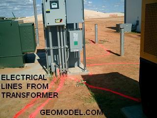
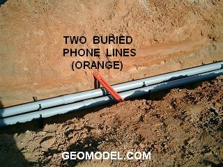
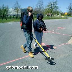
GeoModel, Inc. has conducted numerous ground penetrating radar (GPR) surveys at many sites for utility location using a GPR digital control unit and various transducers (antennas). A utility line can be made of metal, PVC, or any other material that has different dielectric or conductive properties than the surrounding subsurface soils or rocks.
Ground penetrating radar (GPR) produces an underground cross-sectional, two-dimensional image of the soils and subsurface features, including location of utilities.
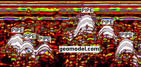
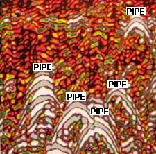
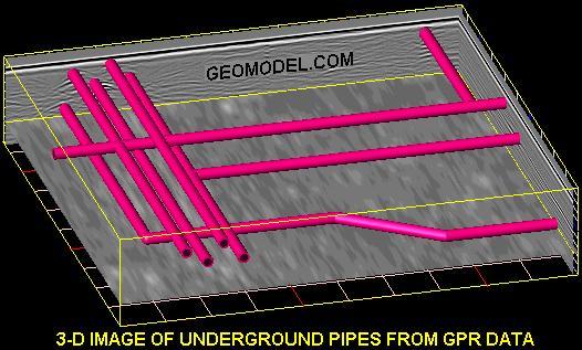
Three-dimensional GPR images for utility location (such as the one below) can be produced using raw GPR field data and post-processing software.
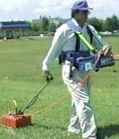
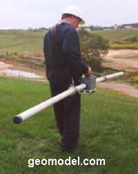
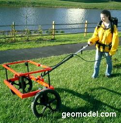
The GPR antenna can be hand-towed or vehicle-towed across the site as shown below.
Ground penetrating radar (GPR) for locating utilities works best in sandy soils. In clayey soils, the GPR signal is attenuated and does not reach as far into the subsurface. Typical depths in sandy soils are 0 to 20 feet, when using the 200-MHz antenna, and 0 to 10 feet, when using the 400-MHz antenna.
In clayey soils, the GPR method may only detect to 3 to 4 feet or less. For locating utilities in clayey soils, GeoModel, Inc. supplements the GPR survey with the Electromagnetic Conductivity, Metal Detection, Multi-frequency, and other methods. GeoModel, Inc. is known for detecting utilties that other locating companies cannnot.
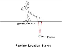
Global Positioning Conductivity Surveys for Utility Location
GeoModel, Inc. offers utility line locating using GPS. Mapping is done automatically using a vehicle or ATV driven system. Results can be obtained in a short time period, making our system cost-effective for locating utilities on large industrial sites, as well as for smaller sites. Metal utility lines, and most other conductive utility lines, are mapped using our unique technique.
ATV-Mounted Utility Location System
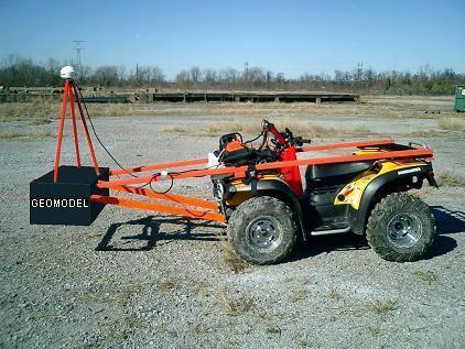
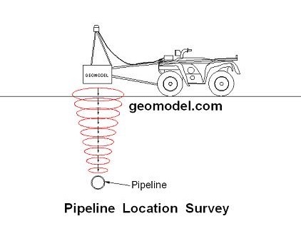
ATV-Mounted Shallow Pipeline Detection System (On Left) and
Shallow EM Metal Detection Signal Transmission into the Subsurface (On Right)
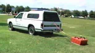
Vehicle-Towed Utility Location System
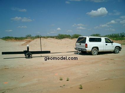
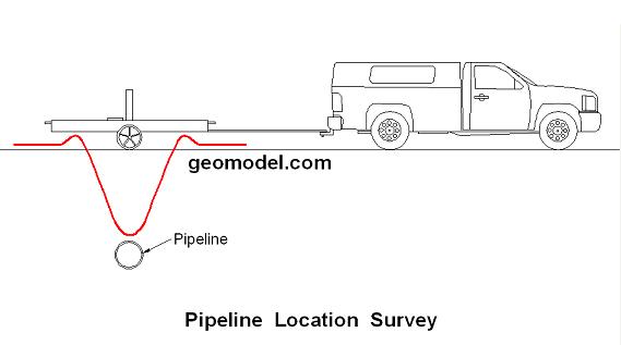
The photos above show the vehicle-towed 18-foot (6-meter) deep EM conductivity meter
and a representation of the EM response to a buried metal pipeline
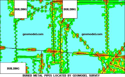
GeoModel Map Example of Utility Location EM Survey
Using the data obtained from the EM conductivity survey, GeoModel, Inc. can create a GeoModel Map of your property. GeoModel, Inc. uses EM and metal detection instruments and computer processing to create a full color GeoModel Map contour map showing areas of buried metal or conductive pipelines and utilities.
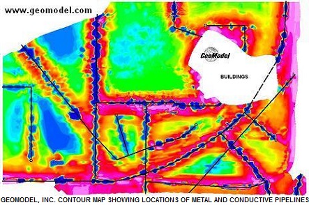
The contoured GeoModel Map above was made by GeoModel, Inc. using an EM instrument to collect field data, data processing software to grid the field data, and post-processing visualization software to produce the color image.
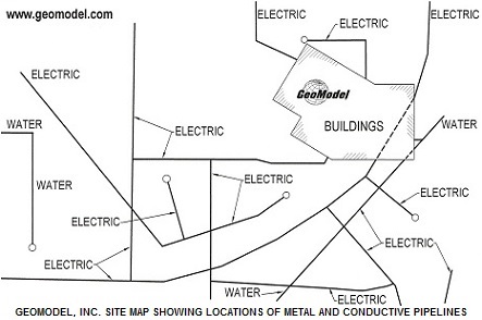
The image on the above right shows the locations of metal and conductive pipelines detected by the EM instrument in the same area as on the color GeoModel Map above.
GeoModel, Inc. can also locate buried drums, underground storage tanks (USTs), or burial trenches containing metal using our specialized field mapping, global positioning, and data contouring system.
Combined GPR and EM Surveys for Utility Location
For utility location surveys, GeoModel, Inc. uses a combination of GPR and EM methods that compliment each other. The two methods together provide a more detailed coverage for utility location. The maps below show one example of how GeoModel used both GPR and EM to locate underground utilities
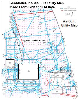
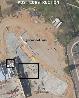
The maps below show a pre-construction aerial photograph, an example utility location "As-Built" site map produced by GeoModel, Inc., and a post-construction aerial photograph. The "As-Built" site map shows the locations of utility lines that were detected using the GPR and EM geophysical methods. The blue lines are the utilities located with only GPR, and the red lines are the utilities located with only EM (metal detection) or by both EM and GPR.
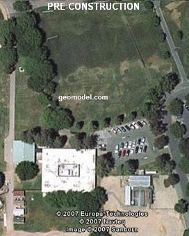
Aerial photograph of survey area (on left),
GeoModel, Inc. As-built utility map based on GPR and EM data (center), and
Post-construction survey area (on right)
Additional Utility Location Techniques
Utility lines made of metal or other conductive materials, including active electrical lines, can also be located using several other types of instruments.
GeoModel, Inc. has conducted numerous electromagnetic conductivity (EM) surveys, metal detector, and multi-frequency surveys to locate metallic buried utilities and electrical cables. GeoModel, Inc. owns and operates various electromagnetic conductivity (EM) instruments, which detect any type of metal utility; a magnetometer, which detects ferrous metal utilities; a UtiLocator, which measures induced current through metal pipes, cables, or PVC pipes with metal wires installed; and a multi-frequency detector that detects active frequencies from 10 Hz to 490 kHz. Pictures of geophysicists and professionals operating these instruments are shown below:
Various EM instruments and metal detectors owned and operated by GeoModel, Inc.
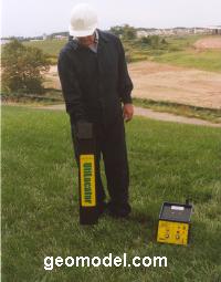
Above left is a magnetometer and above right is a Utilocator
Contour map of EM survey results (above) showing underground metal utilities located by GeoModel
GeoModel, Inc. uses the new EM metal detector which is twice as accurate as the standard EM metal detector.
Other metallic buried objects, such as buried tanks (UST) and buried drums, can also be easily located with the EM or magnetometer instruments.
Company Background
GeoModel, Inc. was founded in 1991 as a geophysical services, utility location, and environmental consulting firm. The company principals have over 50 years of combined experience and have conducted numerous utility location surveys worldwide.
All utility location projects are conducted or supervised by registered professional geologists. GeoModel, Inc. uses GSSI (Geophysical Survey Systems, Inc.) GPR equipment to conduct its GPR survey services.
For a ground penetrating radar survey, click on your state below:
e-mail: ![]() geomodel@geomodel.com
geomodel@geomodel.com
 [Back to Top of page][Back to GPR Applications page]