
Ground Penetrating Radar GPR Survey Services Conducted Nationwide
Email: geomodel@geomodel.com
or Call Us at: 703-777-9788
All GPR surveys are conducted by:
![]() Licensed Professional Geologists with 20 Years of Experience
Licensed Professional Geologists with 20 Years of Experience
![]() 40-Hour OSHA Hazwoper-Trained Professionals
40-Hour OSHA Hazwoper-Trained Professionals
![]() ISNetworld Member Company
ISNetworld Member Company
![]()
![]()
Ground Penetrating Radar Applications
Click on text links below:
![]() utility location
utility location
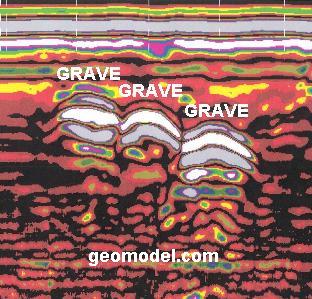
![]() cemetery and grave location
cemetery and grave location
![]() sinkhole and void detection
sinkhole and void detection
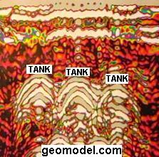
![]() tank (UST) and drum location
tank (UST) and drum location
![]() concrete and rebar inspection
concrete and rebar inspection
![]() geology and geologic hazards
geology and geologic hazards
![]() landfills and burial trenches
landfills and burial trenches
![]() archaeological studies
archaeological studies
CNN and FOX News came to the office of GeoModel, Inc. to find out about Ground Penetrating Radar (GPR).

CNN interviews GeoModel, Inc. about Ground Penetrating Radar GPR.
To view the CNN video interview, Click on the image to the right:

Fox News interviews GeoModel, Inc. about Ground Penetrating Radar GPR.
To view the FOX video interview, Click on the image to the right:
Ground Penetrating Radar
GeoModel, Inc. is registered with the FCC and uses only FCC-approved GSSI GPR equipment
Ground penetrating radar GPR produces an underground, cross-sectional, two-dimensional image scan of the soils and subsurface features.
GeoModel, Inc. conducts ground penetrating radar GPR surveys using antennas with various frequencies.
Depths of GPR underground scans can be as deep as 20 to 30 feet in sandy or silty soils, using a low frequency GPR antenna.
A higher frequency antenna can examine the near surface, to a depth of 12 feet, in greater detail.
If your site has clayey soils, then the ground penetrating radar signal does not go as deep, no matter which frequency antenna is used.
For more information about What is ground penetrating radar and how does it work?,Click Here
Shallow Ground Penetrating Radar Surveys
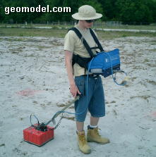
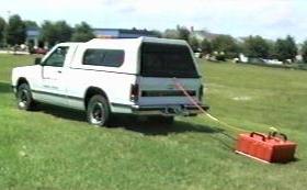
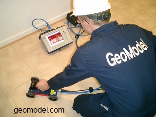
Shallow ground penetrating radar GPR surveys are conducted by one person, hand-towing or ATV-towing the antenna.
Applications for a shallow ground penetrating radar survey include:
![]() locating pipelines and utilities,
locating pipelines and utilities,
![]() locating underground storage tanks (USTs) and drums,
locating underground storage tanks (USTs) and drums,
![]() locating unmarked gravesites, and
locating unmarked gravesites, and
![]() conducting archaeological studies.
conducting archaeological studies.
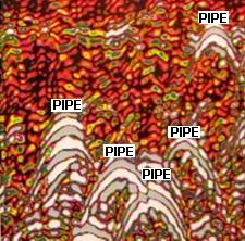
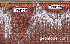
Deep Ground Penetrating Radar Surveys
Deep ground penetrating radar GPR surveys are conducted with a low frequency GPR antenna, such as a 200-MHz antenna that can reach depths of up to 20 to 30 feet in sandy soils. In clay soils, the depth reached is less.
Applications for deep ground penetrating radar include:
![]() landfill and burial trench delineation,
landfill and burial trench delineation,
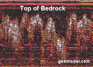
![]() geology and bedrock depth studies, and
geology and bedrock depth studies, and
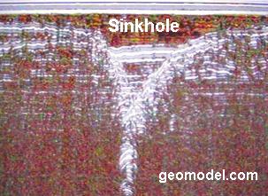
![]() karst and sinkhole location.
karst and sinkhole location.
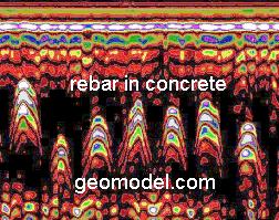
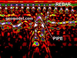
Concrete Inspection Surveys
GeoModel, Inc. can conduct ground penetrating radar (GPR) underground scanning of concrete to locate rebar, pipes, and conduits in concrete structures. Our scanning can also detect voids within concrete slabs and under concrete slabs.
Our ground penetrating radar scanning can inspect concrete walls, concrete floors, slabs, airport runways, tunnels, abutments, dams, and garages.
Cemetery and Grave Site Surveys
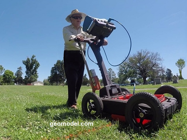
GeoModel, Inc. conducts ground penetrating radar surveys for locating unmarked grave sites and confirming marked grave sites at cemeteries.
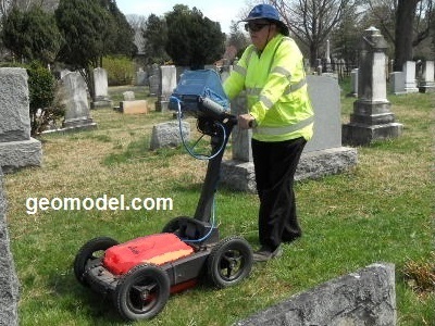
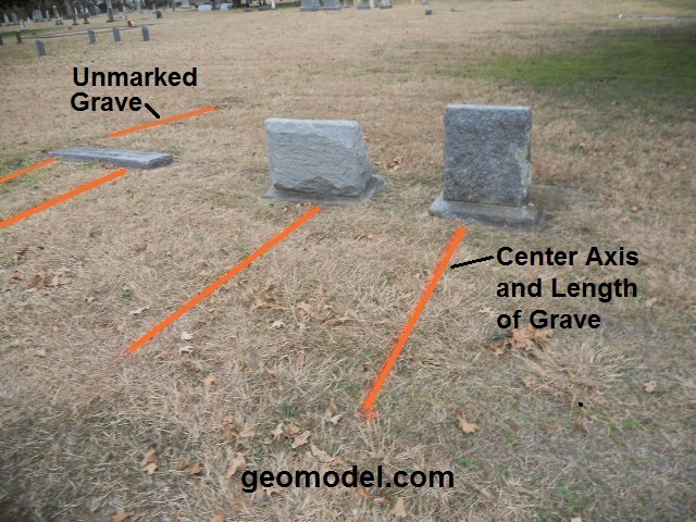
GeoModel, Inc. operator using the GPR survey cart system (above left) and locations of marked and unmarked graves painted on the ground with a line of paint down the center axis of the grave and for the length of the grave (above right).
GeoModel Heat Map Surveys
GeoModel, Inc. can create a color-contoured GeoModel Heat Map of your property that represents the features present below ground.
The GeoModel Heat Map shows areas of low EM "heat" values (light blue to green colors) and areas of increased EM "heat" values (yellow to red colors)
Low heat values may represent natural, background, or dry soil conditions.
High heat values are indicative of landfills, low pH or salt contamination, or increased groundwater flow.
Very low EM values (deep blue) usually represent buried metal features or objects,such as metal utilities, tanks or drums.
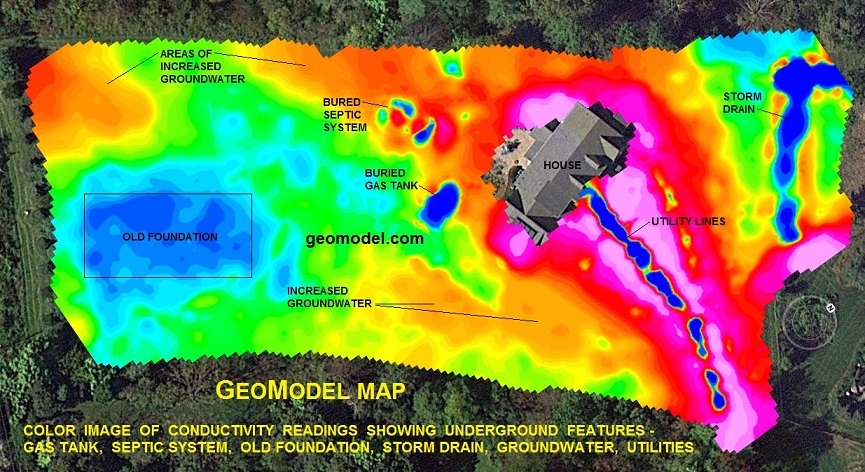
The color-contoured image (Google GeoModel Heat Map) above was obtained using an EM survey with GPS positioning. The various colors represent different underground features.
For a GeoModel Heat Map, mapping is done automatically using a vehicle or ATV driven EM survey system.
EM data results can be obtained in a short time period, making our system cost-effective for large industrial sites, as well as for smaller sites.
Metal utility lines, and most other conductive utility lines, are mapped using our unique EM survey technique.
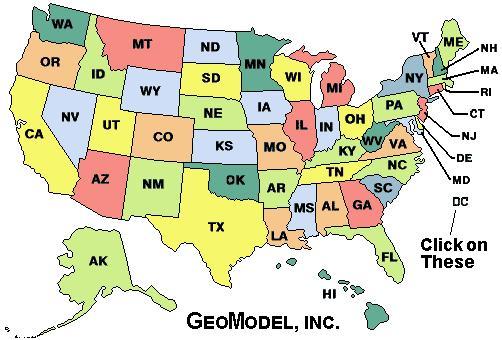
For a ground penetrating radar survey,
or GeoModel Heat Map EM survey
click on your state below:
e-mail:geomodel@geomodel.com
or Call Us Today: 703-777-9788
[Back to Top of Page]