
What is Ground Penetrating Radar?
Email us at geomodel@geomodel.com or phone 703-777-9788
What is Ground Penetrating Radar and how does GPR work?
Ground penetrating radar (GPR) is a nondestructive geophysical method that produces a continuous cross-sectional profile or record of subsurface features, without drilling, probing, or digging. The GPR cross-section shows the ground surface at the top of the profile, and the reflections of subsurface geologic units and objects to a certain depth at the bottom.
Ground penetrating radar (GPR) profiles are used for evaluating the location and depth of buried objects and to investigate the presence and continuity of natural subsurface conditions and features, as seen in the two examples below.

How Does Ground Penetrating Radar Work?
Ground penetrating radar operates by transmitting pulses of ultra high frequency radio waves (microwave electromagnetic energy) down into the ground through a transducer (also called an antenna).
GeoModel, Inc. 400-MHz Antenna (on left) and 200-MHz Antenna (on right)
(Manufactured by GSSI - Geophysical Survey Systems, Inc.)
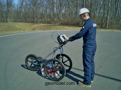
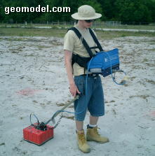
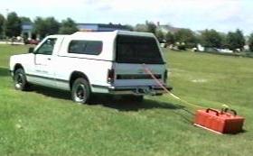
The ground penetrating radar antenna (transducer) is pulled along the ground by hand or behind a vehicle.
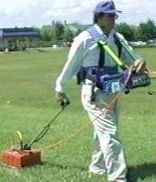

Hand-towed 400-MHz antenna GPR Survey and Vehicle-towed 200-MHz antenna GPR survey
The transmitted energy is reflected from various buried objects or distinct contacts between different earth materials.
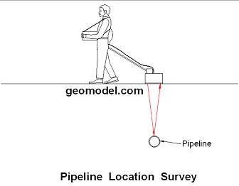
Diagram showing how the GPR signal reflects from a Buried Pipe and returns to the GPR antenna
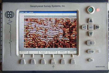
The antenna then receives the reflected waves and stores them in the digital control unit.
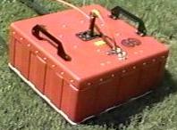
GeoModel, Inc.'s SIR-3000 GPR Digital Control Unit
(Manufactured by GSSI - Geophysical Survey Systems, Inc.)
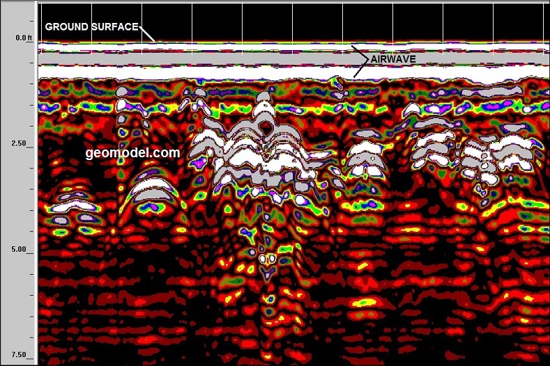
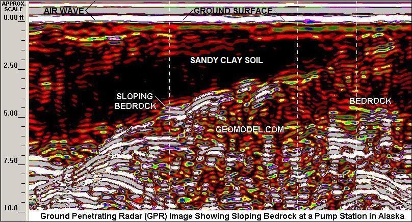
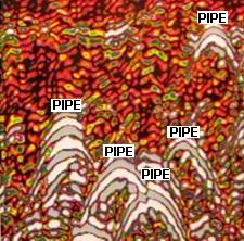
The GPR antenna needs to have good contact with the ground surface in order for the GPR antenna to register the ground surface. When the GPR antenna signal does this, it creates an "air wave" as shown in the GPR image below.
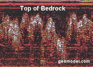
When the transmitted signal enters the ground, it contacts objects or subsurface strata with different electrical conductivities and dielectric constants. Part of the ground penetrating radar waves reflect off of the object or interface; while the rest of the waves pass through to the next interface. On the right side of the bedrock GPR image below, the sloping bedrock layer can be seen above a horizontal bedrock layer.
The reflected signals return to the antenna, pass through the antenna, and are received by the digital control unit. The control unit registers the reflections against two-way travel time in nanoseconds and then amplifies the signals. The output signal voltage peaks are plotted on the ground penetrating radar profile as different color bands by the digital control unit.
For each reflected wave, the radar signal changes polarity twice. These polarity changes produce three bands on the radar profile for each interface contacted by the radar wave.
The depth scale for the GPR profile is calculated from the two-way travel time in nanoseconds and the dielectric constant (DI) of the subsurface soils or rocks.
How Deep Can Ground Penetrating Radar Go Into the Ground?
The depth to which ground penetrating radar waves can reach beneath the ground surface is mainly dependent on two conditions: 1) the type of soil or rock in the GPR survey area, and 2) the frequency of the antenna used.
Ground penetrating radar can reach depths of up to 100 feet (30 meters) in low conductivity materials such as dry sand or granite. Moist clays, shale, and other high conductivity materials, may attenuate or absorb GPR signals, greatly decreasing the depth of penetration to 3 feet (1 meter) or less.
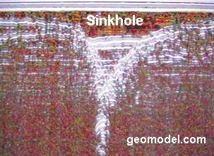
The depth of penetration is also determined by the GPR antenna used. Antennas with low frequencies of from 25 to 200 MHz obtain subsurface reflections from deeper depths (about 25 to 100 feet or more), but have low resolution. These low frequency antennas are used for investigating the geology of a site, such as for locating sinkholes or fractures, and to locate large, deeply buried objects.
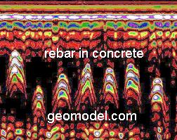
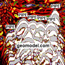
Antennas with higher frequencies of from 300 to 1,500 MHz obtain reflections from shallow depths (0 to about 18 feet), and have high resolution. These high frequency antennas are used to investigate surface soils and to locate small or large, shallow, buried objects, such as utilities, gravesites, and also rebar in concrete.
GeoModel, Inc. conducts ground penetrating radar surveys using a SIR-3000 digital control unit and various antennas with frequencies ranging from 200 to 1,500 MHz. The GeoModel, Inc. principals have over 50 years of combined experience and conduct GPR surveys nationwide. GeoModel, Inc. professionals are known for locating utilities and other buried features that other less-experienced companies cannot locate.
Ground Penetrating Radar Applications
Where do ![]() and
and  get their information on ground penetrating radar?
![]()
Ground Penetrating Radar
GeoModel, Inc. is registered with the FCC and uses only FCC-approved GPR equipment
Ground penetrating radar (GPR) produces an underground, cross-sectional, two-dimensional image scan of the soils and subsurface features. Three-dimensional GPR images, such as the one below, can be produced using raw field data and post-processing software.
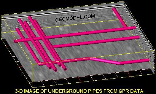
GeoModel, Inc. conducts ground penetrating radar (GPR) surveys using antennas with various frequencies. Depths of GPR underground scans can be as deep as 25 to 35 feet (8 to 11 meters) in sandy or silty soils, using a low frequency ground penetrating radar antenna.
A higher frequency antenna can examine the near surface, from 0 to 12 feet (0 to 3.6 meters), in greater detail. The ground penetrating radar signal does not go as deep (as little as 1 to 3 feet) in clayey soils.
Shallow Ground Penetrating Radar Surveys
Shallow ground penetrating radar surveys are conducted by one person, hand-towing or ATV-towing the antenna, and can examine the near subsurface from 0 to 12 feet (0 to 3.6 meters) below the ground surface.
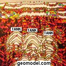
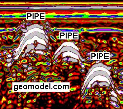
Applications for a shallow ground penetrating radar survey include locating pipelines and utilities using a 4-way scan, locating underground storage tanks (USTs) and drums, inspecting concrete, detecting rebar, locating unmarked gravesites, and conducting archaeological studies.
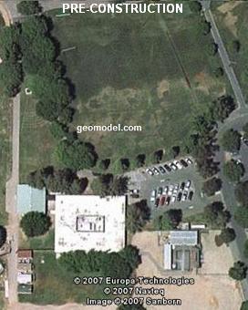
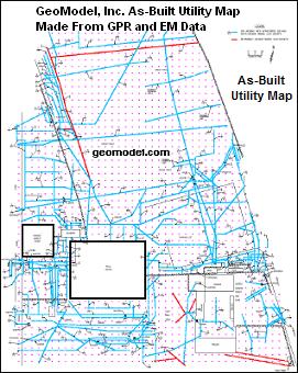
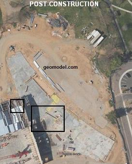
Before GeoModel, Inc. survey (left), GeoModel, Inc. As-built utility map (center), and area after construction (right)
Deep Ground Penetrating Radar Surveys
Deep ground penetrating radar underground scanning surveys are conducted with a low frequency GPR antenna, such as a 200-MHz antenna that can reach depths of up to 35 feet in sandy soils.
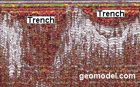
Applications for deep ground penetrating radar include landfill and burial trench delineation, geology and bedrock depth studies, and karst and sinkhole location.
Concrete Inspection Surveys
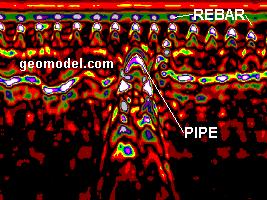
GeoModel, Inc. can conduct ground penetrating radar (GPR) underground scanning of concrete to locate rebar, pipes, post tension bars, and conduits in concrete structures. Our scanning can also detect voids within concrete slabs and under concrete slabs.
Our ground penetrating radar scanning can inspect concrete walls, concrete floors, slabs, airport runways, tunnels, abutments, dams, and garages. Asphalt roads and surfaces can also be scanned.


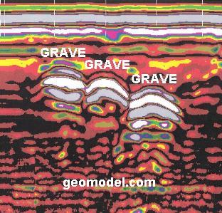
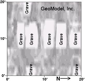
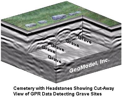
Cemetery and Grave Site Surveys
GeoModel, Inc. conducts ground penetrating radar surveys for locating unmarked grave sites and confirming marked grave sites at cemeteries.
GeoModel, Inc. uses GSSI (Geophysical Survey Systems, Inc.) GPR equipment to conduct its GPR survey services.
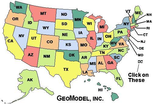
For a ground penetrating radar survey, click on your state below:
e-mail: ![]() geomodel@geomodel.com
geomodel@geomodel.com
 [Back to Top of Page] [Go to Ground Penetrating Radar Survey Services Website]